-
About Union
ইউনিয়ন পরিচিতি
Geographical & Economic
Miscellaneous
-
ইউনিয়ন পরিষদ
Union Council:
Activities of Union Council
Village Adalat
-
সরকারী অফিস
Agriculture
Land
Health Services
Social Service
-
Other Institutions
Educational Institutionsশিক্ষা প্রতিষ্ঠানের তালিকা
Religious Organizations
-
Different Lists
List of Beneficiaries
- Projects
-
Services
UDC
National E-Service
- Gallery
-
About Union
Annual purchase plan
ইউনিয়ন পরিচিতি
Geographical & Economic
Miscellaneous
-
ইউনিয়ন পরিষদ
Union Council:
Activities of Union Council
Village Adalat
-
সরকারী অফিস
Agriculture
Land
Health Services
Social Service
-
Other Institutions
Educational Institutionsশিক্ষা প্রতিষ্ঠানের তালিকা
Religious Organizations
-
Different Lists
List of Beneficiaries
- Projects
-
Services
UDC
National E-Service
-
Gallery
Photo Gallery
Video Gallery
Location: Naruya Union located 8 kilometers west of Baliakandi upazila of Rajbari district. The union is a beautiful and
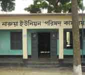
Located in the beautiful surroundings of Naruya Bazar, the Union Parishad Complex building is located. Baliakandi Union, Magura district and Gorai river on the west and south and Mirgi union of the Kalukhali upazila on the east and Jungle Union in the south. The size of the union is 24.74 sq km. During the British rule, during the tenure of the Land Meyer, the current union council started in 1960, named as Gram Panchayet. According to the 2011 Census, the population of the union is 25753 and the number of people is 6,445. Literacy rate among the town people is 44.59%. Main crops include jute, piazza, garlic, paddy, wheat etc. Information related to union:
Union name, address Naruya Union, Upazila: Baliakandi, District: Rajabari
LGED ID No. 3820785 of Union Parishad
Volume 24.74 square kilometers
Wade 9
Village 37
Mouza 21
Population 25753 (according to census 2011)
Literacy rate among the town people is 44.59%
Educational institutions: Primary schools: 17, high school 3, college: 2, madrasa 3, poetry madami-1
Mosque 40
Temple 9
Hats and bazars are 3 (1. Naruya Bazar, 2. Ghikamla Bazar, 3. Gorkola Bazar)
River 1 (garai river)
Khayaghat 3 (1. Naruya Khyaghat, 2.Sonakandar Khayaghat, 3. Kanagram Khayagat)
Sanitation Coverage (According to Brake Wash's Information)
Bridge 12
Cortex 20
The three
Cremation 5
Gothan 11
Main agricultural products Jute, piazza, garlic, rice, wheat etc.
Sluice Gate 3
Banks and other institutions Grameen Bank, Brac, Asha, Bruro Bangladesh, Janata Bank Limited
Government office union land office 1, union agriculture office 1, family welfare center 1, community clinic 3.


Planning and Implementation: Cabinet Division, A2I, BCC, DoICT and BASIS
Technical Assistance:
![]()
Developed By: